The Once and Future River

In a park along the industrial banks of the Los Angeles River, roughly a mile northeast of where the Los Angeles Dodgers play home games, Matthew Teutimez pulls on the stem of a sickly native plant, installed here by well-meaning ecologists to at least hint at what this land once was: a resource so profound and productive that the indigenous Kizh tribe built their civilization around it. “They’re forcing vegetation in areas that it doesn’t want to be,” says Teutimez, who serves as the Kizh tribe’s official biologist. He holds between his fingers a small rose hip, the nutrient-rich fruit of the rose plant, struggling to survive among the encroaching Bermuda grass. “This isn’t restoration when we do this,” he says. “It’s revegetation.”
Teutimez, who makes his living as an independent consulting ornithologist on environmental studies, puts air quotes around the word “restoration” when he uses it in the context of projects for the river. Restoration would mean more planting specimens of native foliage; it would mean digging swales to absorb falling water and replenish the aquifer. It would mean giving back to the Los Angeles River and all of its creeks and tributaries their natural functions – their power to move rocks, to accrete land, to build dunes and barrier islands at the coast. To nourish free-growing flora, including medicinal plants and those that absorb pollutants before water percolates into the ground or continues downstream. To offer relief and refreshment: A place to wait out a summer afternoon in the shade of a willow, barefoot in the shallow mud.
When the policymakers of Southern California wonder what to do with their wrecked rivers – not just the Los Angeles but the Santa Ana to the south and the San Gabriel to the east – how the Kizh people lived with them for so many thousands of years is rarely, if ever, considered. By the time city engineers such as William Mulholland and James Reagan began plotting the river’s demise, the native people had been erased, rewritten as mythological nomadic wanders who moved as the river cycled through its floods and droughts. But it isn’t true, Teutimez insists, that myth of natives as rootless only became popular in the early 20th century. “It meant we had no ownership of the land,” he says. “No sense of place.”
Such is the tragedy of Southern California nature: The erasure of a people also meant the erasure of a way of life, and a way of living with the natural cycles of dry years and floods that defines this coastal climate.
They were also renamed, first as the Gabrieleño Indians, after the late 18th-century mission where the Spanish enslaved them, and later as the Tongva, a misnomer coined by ethnographer and naturalist C. Hart Merriam in 1903, who might have mistakenly applied the name of a single village to an entire tribe based on a single woman’s (misinterpreted) account. Kizh, pronounced “Keech,” predates both names, and means “house.” Those houses were built with willow branches harvested from the river’s bed and banks, Teutimez says, “because of its tensile strength.” On the left-hand side of his shirt is an embroidered example of a willow Kizh: a golden dome, which the Kizh understood was the strongest building design long before Buckminster Fuller came along. Early white settlers knew this too: Where the willows grew in the riverbed, people in the early 20th century told James Reagan, floodwaters slowed; planting more of them was one strategy they deployed against inundation.
Such is the tragedy of Southern California nature: The erasure of a people also meant the erasure of a way of life, and a way of living with the natural cycles of dry years and floods that defines this coastal climate. In the process of displacing and murdering and forcibly converting the Kizh to their bastard notion of Christianity, European settlers also dismissed the wisdom of a people who knew not just how to live lightly and symbiotically with Southern California as they found it: wet, dry or aflame.
Maybe it’s true that the great forward-thinking engineers of the early City of Los Angeles had to import water from the mountains as more people moved in; Mulholland’s gravity-fed aquifer, which drains water from the Owens River Valley in the shadow of the Eastern Sierra, certainly allowed the population to grow beyond its natural carrying capacity. (Other imported water from the California Delta and — to a lesser extent the Colorado River — has, too.) But none of that importing and growing necessitated straightening the meanders of the rivers and hardening the riverbeds and diverting ephemeral natural streams underground. That was done because early regional planners constructed their civilization with only dry years in mind. They settled in flood-prone valleys and farmed in alluvial plains, and so were taken aback when significant rainstorms washed away homes and people and cars and thoroughfares and the San Gabriel Mountains sent rocks and mud cascading downslope at deadly speeds.
A river couldn’t be a river if it reared up every fifth winter and shrank to a trickle the rest of the time. It had to be more predictable. It had to behave. By the late winter of 1938, when back-to-back storms swelled every southland waterway from San Gabriel to Compton to Santa Ana, people had had enough of water. Incomplete dams were finished, new ones went up, and with federal funding from the 1941 Flood Control Act, the U.S. Army Corps of Engineers cemented the Los Angeles River in place. Over time, another 278 miles of streams, washes and tributaries in the river system were condemned to live out the rest of their natural lives as buried storm drains. All the garbage and animal droppings and discarded needles that land in the 834-square mile watershed follow these routes quickly to the sea, which is why you can’t safely surf or swim near a culvert after a big rainstorm. But at least you’re less likely to drown in an inland flood.
By building up places that were meant to lay fallow and controlling floods to the exclusion of every other ecological consideration, the eminent designers of the Southern California landscape have put us all in a pickle. Painted us into a corner, you might say – a dry corner, a temporarily safe one, but one from which escape will be difficult, if it’s possible at all. Now, as the mountains of the Sierra dry up, as the Colorado River empties out, as Southern California knocks down all-time high-temperature records like bowling pins, a healing current of clean water, flanked by green open space where the floodwaters have room to rise, is something we could desperately use. But, it appears to be lost to us. And as one celebrated architect’s blueprints prove, we’re not even really trying to get it back.
Somewhere in the middle of the last decade, Frank Gehry turned his attention to the River. I guess we were supposed to be flattered: The architect who built Disney Hall and the Guggenheim Museum in Bilbao, Spain and all sorts of other wonderful structures had deigned to propose a plan for the lower Los Angeles River, where the Rio Hondo (“deep river” in Spanish) flows into the Los Angeles between Downey and South Gate. The proposed overhaul of the site will feature a swanky new park, a cultural center, vegetated platforms and equestrian paths. It will revitalize neighborhoods that were industrialized by the channelization of this stretch of the river, and capture some falling rain and runoff for the groundwater basin, which is a commercial enterprise: Coca-Cola bottles Dasani water in Downey, San Leandro and Anaheim. (I have always suspected the water’s name came from those three locales but can’t get Coca-Cola’s spokespeople to admit it.)
What the Gehry plan won’t do is, to borrow from Cadillac Desert author Marc Reisner, right any of the wrongs “done by earlier generations doing what they thought was right.” No concrete will be removed for this project (but some will be added); no meander redrawn nor willow replanted in the riverbed. The project could go forward with or without a river, and for all its good-hearted liberal intentions (a “watershed education plan” is built into the design), it will not teach anyone who isn’t already interested about the functional splendor of a natural river. The plan, simply put, doesn’t include nature.
“What are they trying to restore it to? Are we trying to get use out of it, or are we just trying to make something that you can bring tourists to and say, ‘Look how pretty that is!’”
“Do you know what an upland ecological zone would look like if it were composed of the right riparian components?” Teutimez asks. We are standing in Steelhead Park in the golden light of the late afternoon, looking around at the rough patches of vegetation left to fend for themselves against the concrete and invasives. No one who walks the paths of the Gehry-renovated Los Angeles River will learn to even understand his question.
Teutimez could explain it to them, though, as part of a story about the Kizh and the tribes’ attitude towards nature, in which everything had a purpose in the Creator’s plan. (“I don’t want to talk about God too much,” he says, “but I do have a rather biblical view of the world.”) He admits that at the moment, the trend is going in the wrong direction. The Gehry plan hasn’t been tagged with a price, except for a Southeast Los Angeles Cultural Center which will cost an estimated $150 million. But for the kind of time and money it’s inevitably going to take, you could rip out a lot of concrete and buy back a lot of the floodplain parcels and build several affordable multi-family buildings in the safe zone. You could restore a healthy upland ecological zone with riparian components that could take carbon dioxide out of the air and provide habitat. If none of that is in the proposal, then, Teutimez asks, “What are they trying to restore it to? Are we trying to get use out of it, or are we just trying to make something that you can bring tourists to and say, ‘Look how pretty that is!’”
A river would be pretty, I think when he says this. I wonder what it would be like, in a Los Angeles winter, to walk to the Tujunga Wash a quarter-mile down the hill from where I live, and see it sweeping past vegetation, churning up mud. Right now a trickle of a stream runs parallel to the high fence that protects the walking and biking path from the deep concrete channel dug for the wash in the 1950s, and dug deeper after a 1969 flood ripped apart some of the earlier channel’s walls. The little creek is a revitalization project installed by the good people of the Mountains and Recreation Conservation Authority in collaboration with Los Angeles County, and the result is darling. The creek has been adorned with benches and interpretative signs, lined with sage and buckwheat and other California natives. It also diverts as much as 325,000 gallons of water a day from the concrete flood control channel to percolate into the aquifer, enough to supply a year-long watersupply for 760 families of four. But no one uses it for recreation. No one sits by the creek to contemplate nature or fish. There are no fish, and signs warn the water is not for drinking. It doesn’t appear to attract much wildlife at all, save the occasional coyote that uses it as easy access to suburban garbage bins. The wash itself, ever since development crowded into its floodplains, remains channelized and dead.
***
It has been more than three decades since politicians and elected officials in both the City and County of Los Angeles began considering a wholesale rehabilitation of the 51-mile-long mostly channelized waterway that authorities insist begins in Canoga Park and empties into the ocean near the Port of Long Beach. Acknowledging that flood-control engineering conducted over a period of time from the 1940s to the 1960s deprived the region and its residents of significant benefits, Los Angeles Mayor Tom Bradley in 1989 declared that one of the goals of his fifth term in office would be the “greening” of the river. By then, the river had been running wet all year round for four years with the treated effluent from city taps, most of it recycled through the Donald C. Tillman Plant in the San Fernando Valley. Certain soft-bottom stretches of the river, such as the Glendale Narrows, where the river starts its southward bend around the Santa Monica Mountains, had become havens for waterbirds. The Los Angeles City Council started hatching a plan to develop riverside bike paths and hiking trails.

Glendale Narrows winds through Glendale, Griffith Park, Atwater Village and Elysian Valley. Photo by Sam Slovick
In 2002, Jenny Price, an author and nature writer, wrote an essay for the L.A. Weekly called “Wet Revolution,” about what then seemed like an irrevocable reversal of the Los Angeles River’s fortunes: a new awareness rising in the city about the “greed [and] power mongering” and the “will to environmental devastation” that had up until then guided Los Angeles water policy.
“We live in a city that has tried to cement its rivers out of existence,” she wrote, but we were headed for a “new era of sanity.” Rainwater would be captured where it falls, wetlands would be restored and parks would sprawl in reclaimed floodplains. It would be done, she believed then, not for the sake of any dewy-eyed back-to-nature fantasy but for simple infrastructural need: By rushing all of our natural water to the ocean down concrete channels, we were sluicing pathogens to the beaches, condemning riverside communities to industrial blight and, most of all, depriving our watershed of its natural right – to collect and retain and purify water so we could summon it up from our ample aquifers when the dry years came.
At the end of the piece, she imagined growing old and flying into the city, looking down at the restored landscape, one where water had returned to its natural courses, flowing from the mountains in glittering fingers of reflected blue, through canyons and washes and all the little streams that once trickled through the Los Angeles Basin, sinking below ground in the hot and dry times and rushing brilliantly in the wet.
I remember that essay well, and not just because I assigned it and edited it, as part of a Best of Los Angeles issue dedicated to imagining the future 10 years on. I remember it because it marked an inflection point in my life as an Angeleno: the moment I understood how recklessly nature had been engineered to disappear in Los Angeles, how it had been literally run underground and paved over for development. I had come from Minneapolis, where water was king – a city settled alongside the mighty Mississippi couldn’t very well encase its creeks in concrete and pretend they didn’t exist. The river in Minneapolis for early settlers drove mills that processed grain and later kept the lights on. In the summer we paddled on it, in the winter we skated on it, and in the fall we walked our dogs through its riparian woodlands where the shallow water table made the colors of leaves more brilliant than they are anywhere I’ve even been.
It was a shock when I came here to learn any river was regarded as a scourge – at best an unpredictable useless annoyance, at worst a menace. But Price was right: By the early 2000s, all signs pointed toward a new future for our local creeks and rivers. Poet and activist Lewis MacAdams had spent the better part of two decades inventing ways to educate the city’s residents on what the Los Angeles River and its tributaries once were and what they could be again. There was an accelerating effort at the city and county level to retain water on land and cease the longstanding practice of, as Price put it, “watering the ocean” via trapezoidal concrete channels designed to do nothing else.
“If you want to see the first chunk of concrete fly,” Price wrote, “camp out on the banks of the Arroyo Seco,” the Los Angeles River tributary that flows through Pasadena. I didn’t even have to camp out – MacAdams called me on my office phone one day to tell me the concrete was flying, and I rushed out to witness Lynne Dwyer of North East Trees overseeing the jackhammers while she gave me a tour of the natural habitat. (“Poison oak,” she told me as I shrank and shrieked from the leaves of three, “is a marvelous habitat plant.”) Tree People founder Andy Lipkis ushered me out to the chronically flood-prone Northeast San Fernando Valley, where the county had just swapped a $42 million storm-sewer project for an underground cistern that would infiltrate and capture more than 2.6 billion gallons, or 8,000 acre-feet, of water every year. That’s only a little more than 1 percent of the water supply of the City of Los Angeles, but it wasn’t meant to stand alone: I and many others thought it was just the beginning of the city’s engineers recognizing the Los Angeles River’s watershed as a resource.
MacAdams had told Price that the Los Angeles River’s rehabilitation was his “40-year art project,” beginning in 1985. She laughed when she heard that, because no one believed it was going to take 40 years from 1985 to fix the river. In 2010, when Lisa Jackson, then-administrator of the U.S. Environmental Protection Agency, came to stand on the banks of Compton Creek, a major tributary to the lower Los Angeles River, to announce that the river and all of its tributaries would thenceforth be regarded as navigable waterways protected by the Clean Water Act, I believed that the river restorers had won. I ran into MacAdams at a party, and congratulated him.
By 2014, even the Corps was on board, offering a $1.35-billion plan to implement “Alternative 20,” a comprehensive plan to enhance habitat, rehabilitate wetlands and revitalize 11 miles of river that runs from Griffith Park south to downtown. This plan even included 8 miles in the Glendale Narrows – a soft-bottom remnant the Corps initially declared too wild to cement.

The Los Angeles River drainage system. Image from Wikipedia
Sadly, as it turns out, “it’s clear that Lewis was way, way optimistic to call the river a 40-year art project,” Price laments. “I mean, how long has the [U.S. Army Corps of Engineers] been saying they’re going to do that eight miles in the Glendale Narrows?
“Seriously, guys,” Price says. “Just do it already.”
To be fair, Price notes, a lot changed in the time she spent in Los Angeles, from 1998 to 2015. After being schooled in the river’s ecology and construction by Melanie Winter, founder and director of The River Project, Price took “literally thousands of people” on tours along the river’s tortured banks. And she did see it change. “They have tons more parks,” she says. “They’ve opened up the river and made it accessible, which is enormously important.” There are bike paths, a bike-up bar, and small revitalization projects like the one where I met up with Matt Teutimez. Two new state parks have been established: Rio de Los Angeles on part of the former freight-switching facility called Taylor Yard (a.k.a. the “G2 parcel”), and Los Angeles Historic Park at River Station across the river. Last year, the Santa Monica Mountains Conservancy approved a $10 million grant, drawn from Proposition 1 — a 2014 state bond initiative that authorized $7.5 billion for water infrastructure — to fund a mile-long river greenway in Glassell Park. The City of Los Angeles and California State Parks hope to combine their efforts to create 100 acres of open green space in the G2 parcel.
The county has also, in January of this year, released a new master plan, which is either evidence of progress or more foot-dragging depending on how long you’ve been in the game. The document defends the concrete in some areas, because it protects downstream communities from floods. Sponges, berms and rain collection devices can’t protect them from peak flows in the event of an extreme storm, its authors argue; only a channelized river can do that. “Between 22,000 and 106,000 people might be displaced if the river were widened three to seven times its current width,” reads a section exploring the possibilities of “holistic river widening.”
In addition to residential displacement, “there would also be major consequences for roads, railways, transmission lines and other public services.” All of which is not to say there’s no place for opening up floodplains. “In places where removing the concrete and widening the river is possible” without displacing residents or existing development, “it should be given great consideration,” said Tensho Takemori, one of the architects involved in the river planning, at a public meeting held last April. It’s all progressive, thoughtful and studied, with an eye toward social and environmental justice. It will offend no one and impress quite a few. Though, what it’s missing is the kind of boldness that leads to radical transformation.
“Where is the vision?” Price asks. “For someone like me, who worked heart, body and soul for so long trying to communicate the benefits” of revitalizing the Los Angeles River, “I’m like, is it ever going to happen? Are you guys ever going to stop planning and measuring? Because right now,” Price says, “it looks like it’ll never be for the people who it was supposed to be for. Gentrification is happening so much faster than [river revitalization],” she says. “And it’s only going to get worse with this Gehry plan.”
“It is,” she says, “profoundly disappointing.”

The Compton-Paramount Connector is an example of a potential project that could be located at one of the proposed project sites identified in the LA River Master Plan. It creates new connections across the LA River and the 710 Interstate with a platform park and a pedestrian bridge. The platform offers a variety of program and habitat areas, as well as a unique elevated view of the LA River. Image from the LA River Master Plan 2021, LA County Public Works, OLIN, Gehry Partners, Geosyntec
The Compton-Paramount Connector, as seen from above. Image from the LA River Master Plan 2021, LA County Public Works, OLIN, Gehry Partners, Geosyntec

A street terminating at the river’s edge is a typical upper river condition in the San Fernando Valley. The proposed design captures and treats local stormwater flow before it enters the river while also providing access and amenities to the adjacent community. Image from the LA River Master Plan 2021, LA County Public Works, OLIN, Gehry Partners, Geosyntec
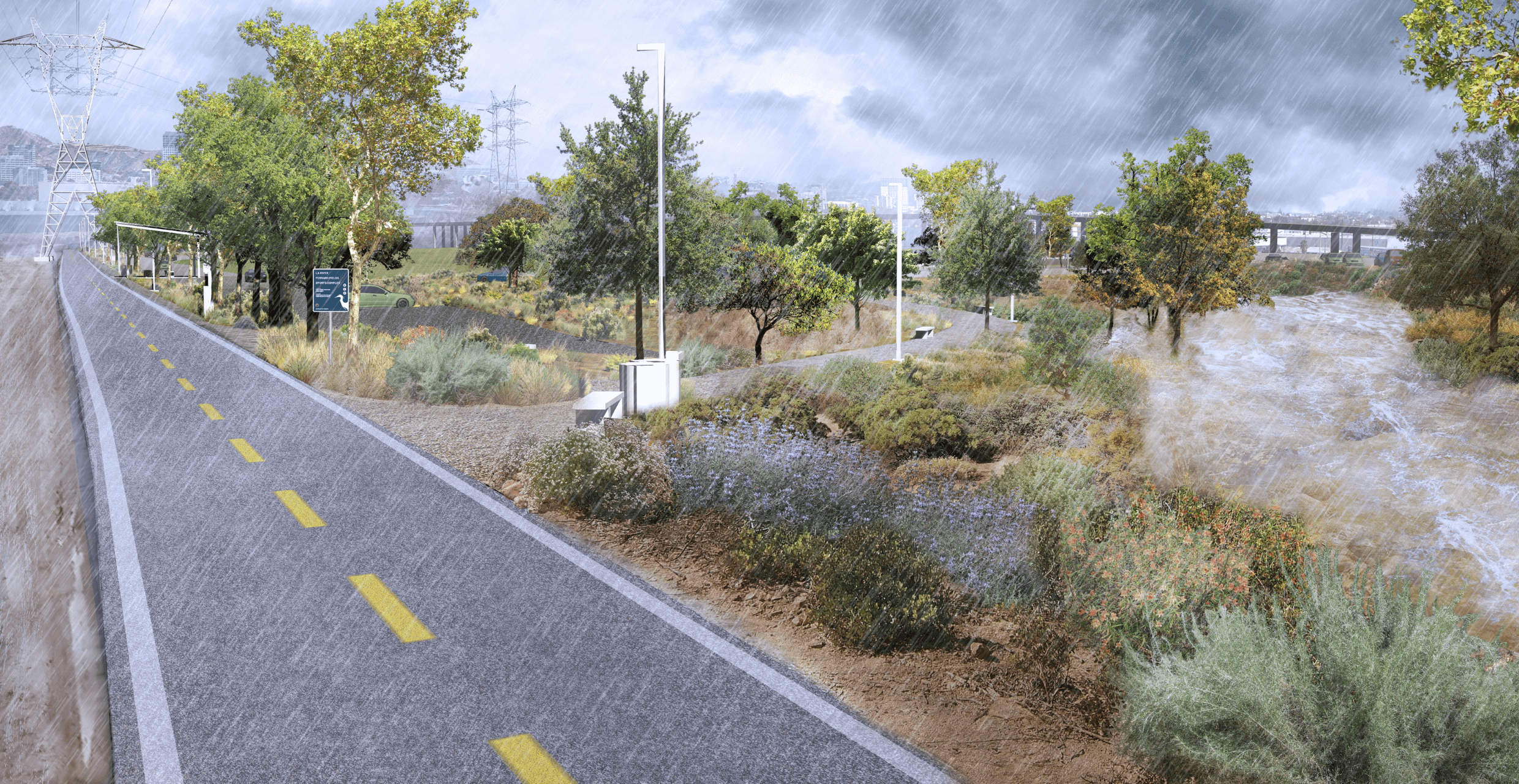
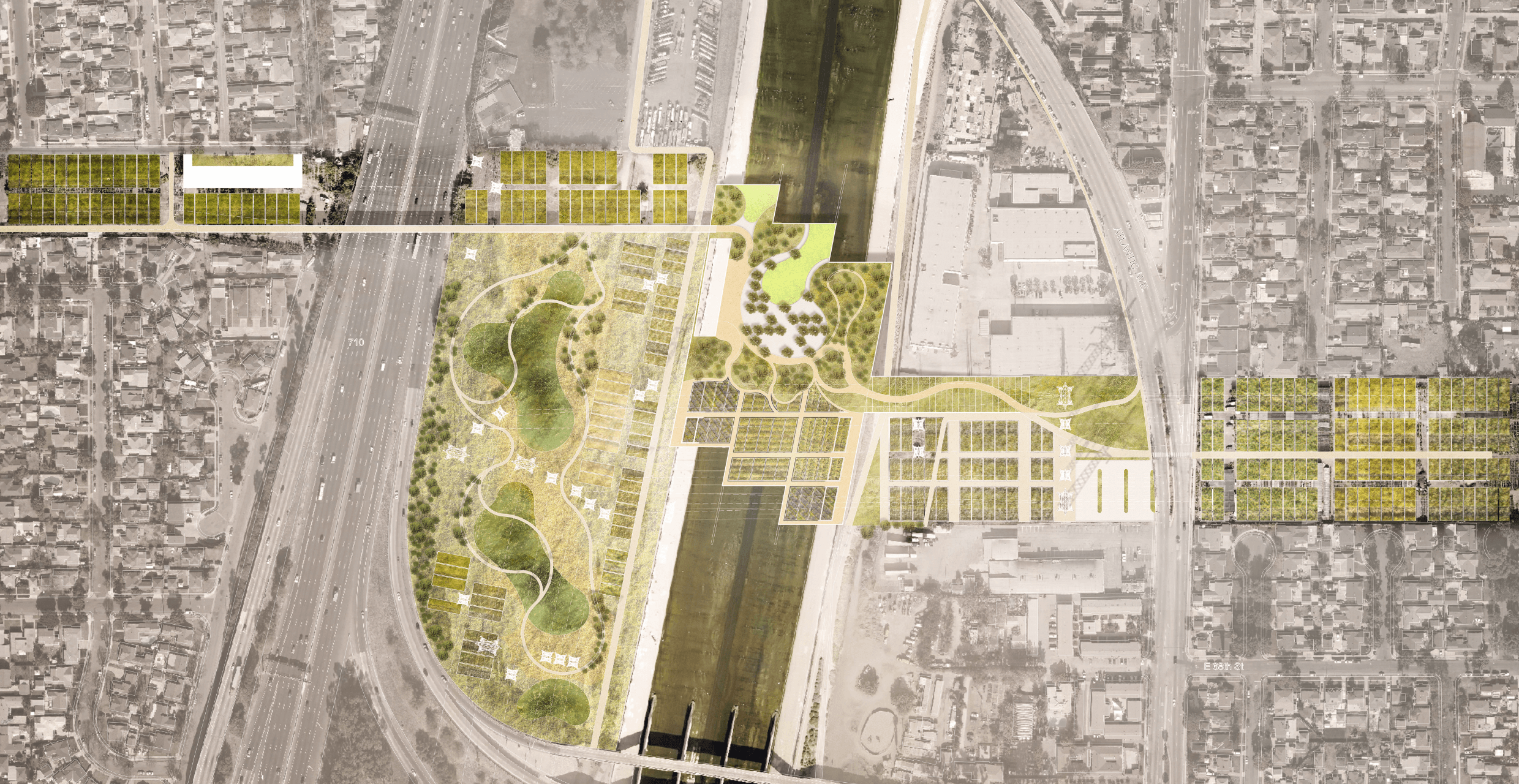
The Ferraro Fields Side Channel is an example of a potential project that could be located at one of the proposed project sites identified in the LA River Master Plan. Nestled between an existing park at Ferraro Fields and the 5 Interstate, it features native plants and dry stream beds and provides additional trails and open space adjacent to the existing athletic fields. During flood events, it plays an infrastructural role, transporting water downstream around this area of higher flood risk. Image from LA River Master Plan 2021, LA County Public Works, OLIN, Gehry Partners, Geosyntec
Click through the left and right arrows to view renderings of the proposed LA River Master Plan.
Gehry and his cohort claim to be acting with the interests of disadvantaged communities in mind, the people who live south of downtown, many of them Black and Latino. U.S. Census figures show that nearly two-thirds of the residents who live near the Los Angeles River south of downtown are low-income; nearly all are either Black or Latino. (In the last count, the Lower Los Angeles River Study Area was only seven percent white.) The decades-long effort to keep water away from people along the length of the river has cemented their green space out of existence.
But it’s hard to see how the Gehry plan helps with that. Concrete platform parks may have been well received in public comments on the new masterplan, but how will they work once built? And how long will they last? Presumably not forever, which means one day they’ll have to be dismantled. Will they truly function as free space, where unpermitted birthday parties can pop up, bounce houses and all? Will Charismatic Catholics be allowed to hold impromptu Sunday-morning church services in Spanish, as they do in wilder city parks? People with dogs and children and no backyards won’t benefit from another half-vegetated urban heat island, or even a cultural center, which implies visitors and traffic and a parking lot, as much as they will from green, cool, free space of the sort that comes from preserving and restoring floodplains.
Woodley in Encino is such a place; it serves as a floodplain for the Los Angeles River, near the Sepulveda Dam. In big rainstorms, the park closes for safety, but most of the year its 80 acres offer free space for cricket games, archery practice, bird walks and dog training. Farther south in Lawndale, Alondra Park has a lake with a native-plant island, baseball diamonds and a skatepark, but also vast stretches of open space for outdoor, socially distanced family picnics during the Covid shutdowns. It’s not a floodplain, but it does have a water-related function: The park is currently being fitted with a stormwater capture system due to open later this year.

The 400-foot-long Taylor Yard Bikeway and Pedestrian Bridge, by SPF:architects, connects Elysian Valley to the Taylor Yard railway site. Photo by Sam Slovick
The Los Angeles River revitalization’s most successful project, the Dominguez Gap Wetlands, does that, too: It previously served as a flood-control basin and later, a spreading grounds, where water could stop long enough to percolate into the groundwater. Since its transformation was completed in 2008, it does all that and more: Vegetation draws up pollutants and sunlight kills pathogens before the water replenishes the aquifer. It’s not completely free space, but it is a place to walk the dog and watch birds, to hike and breathe and bike without the fear or interference of cars. A rare thing, in this ugly, crowded, park-poor metropolis.
A rare thing, too, that these parks and wetlands actually do teach people about nature – not with interpretative signs and plant-name plaques but with circling hawks and resident coyotes and blue heron plucking rodents from their holes; with kayak trips and bird-watching trails that need little upkeep but the regular trampling of feet. When Woodley closes to the public it’s a reminder to everybody that we don’t, after all, live in a desert.
***
The history of Los Angeles is written in its street names, as well as in its remnant willows and sycamores. It is a history of water and swamps and floods. It may seem dry now – very, very dry, as it was before and will be again. Yet last summer, climate scientists at the University of California, Los Angeles, found that just as warmer temperatures make dry periods last longer and heat waves more intense, they also increase rainfall when winter storms come. The state gets more than a third of its water supply every year from atmospheric rivers, long plumes of warm air, heavy with moisture, that swoop up from the tropics to the California coast. The warmer the air, the more moisture it holds, and researchers project that future atmospheric rivers could carry as much as 25 percent more water than current ones. Precipitation that once fell as mountain snow will more often come as rain, increasing flood risks.
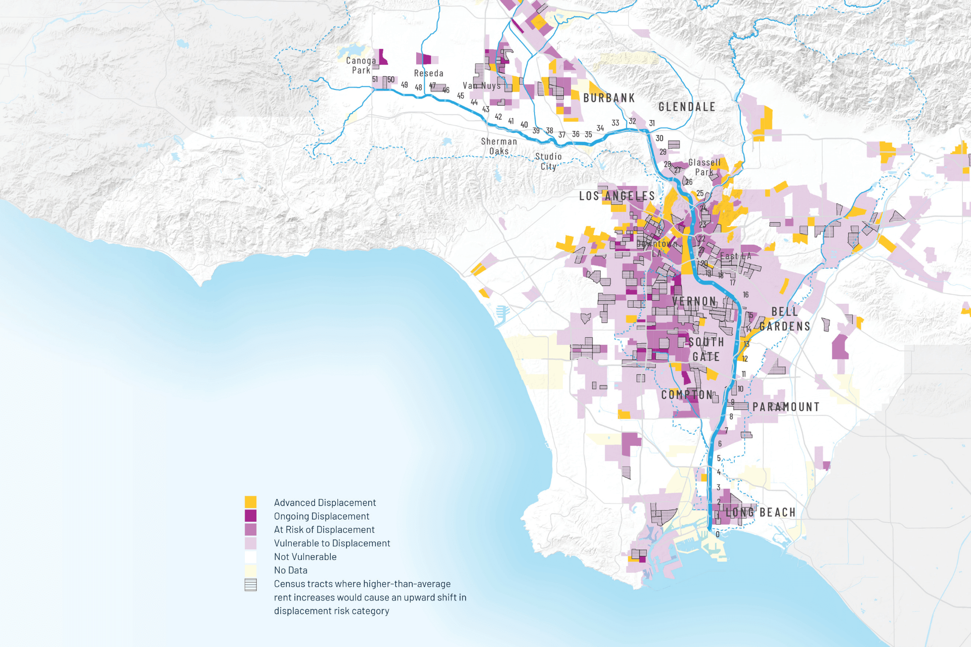
The displacement risk is most pervasive between Downtown L.A. and Long Beach. This map was developed based on research by the Urban Displacement Project. Image from the LA River Master Plan 2021. Source: Chapple, K., Loukaitou-Sideris, A., Waddell, P., Chatman, D., & Ong, P. (2017), “Developing a New Methodology for Analyzing Potential Displacement”
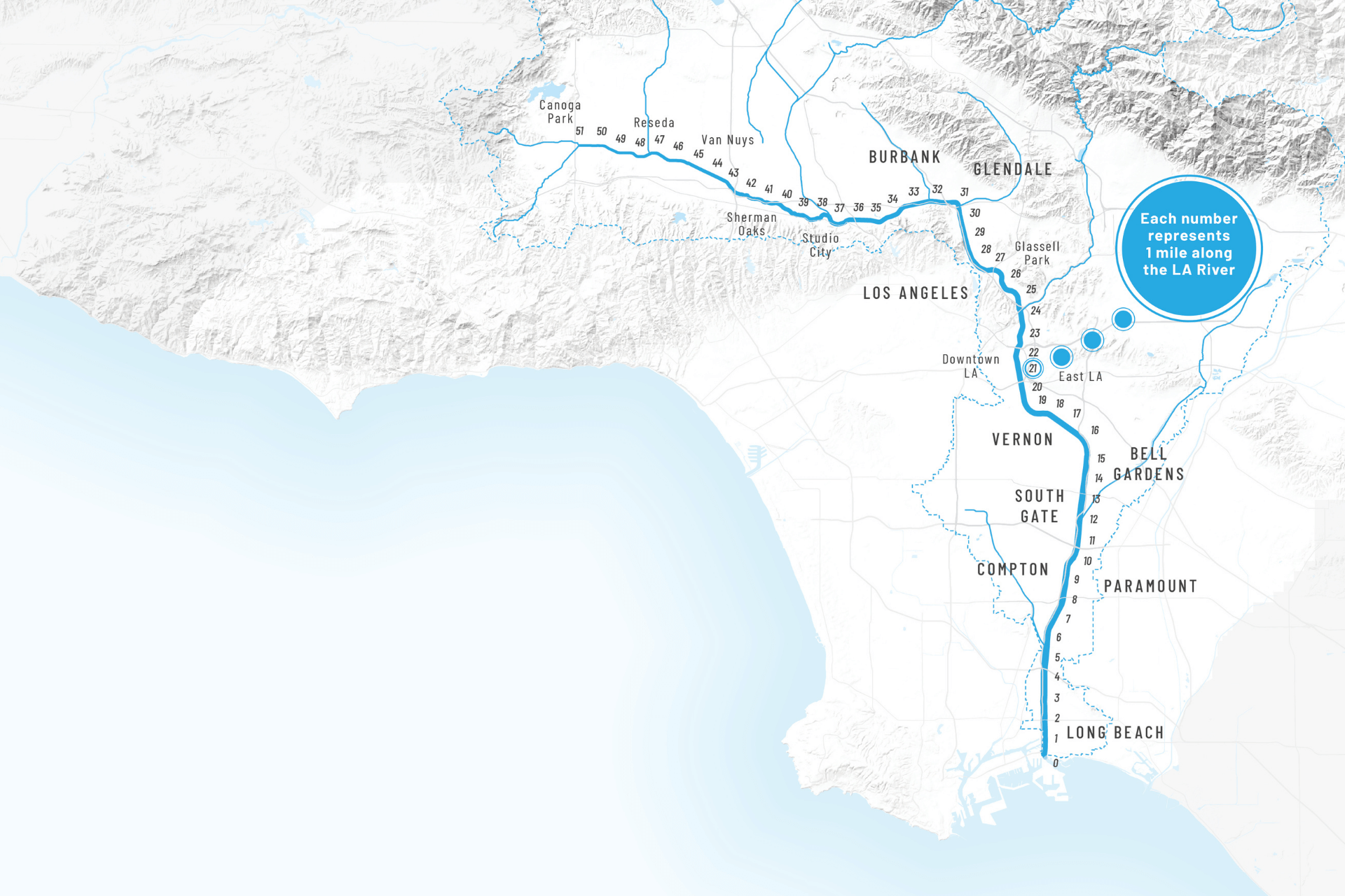
The LA River mile system. Image from the LA River Master Plan 2021
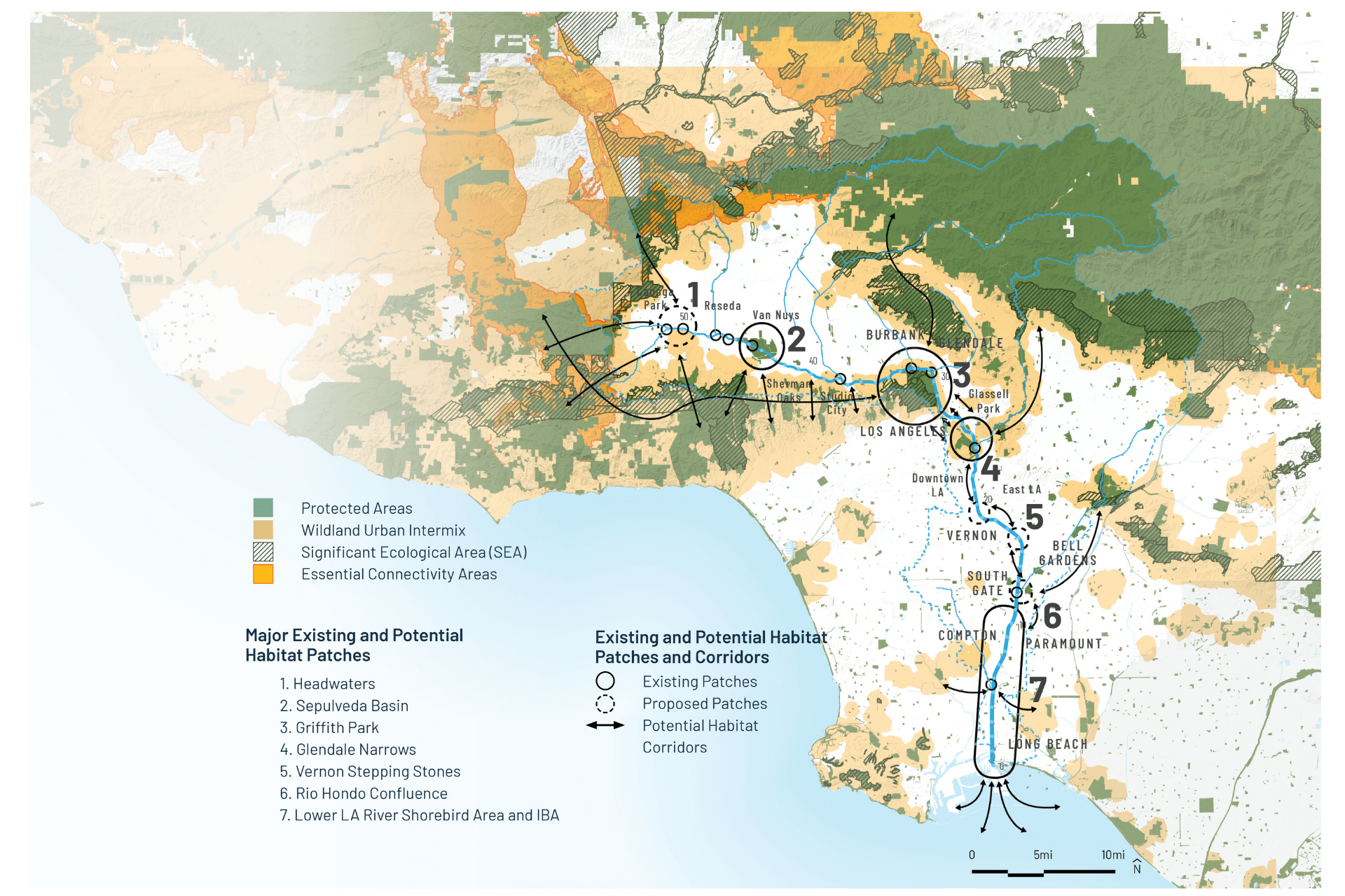
The LA River is a mix of habitat areas. Image from the LA River Master Plan 2021. Source: CDFW and CalTrans, California Essential Habitat Connectivity Project, 2010 & Remote Sensing Lab, Region 5, USDA Forest Service, CA: Wildland Urban Intermix, 2006.
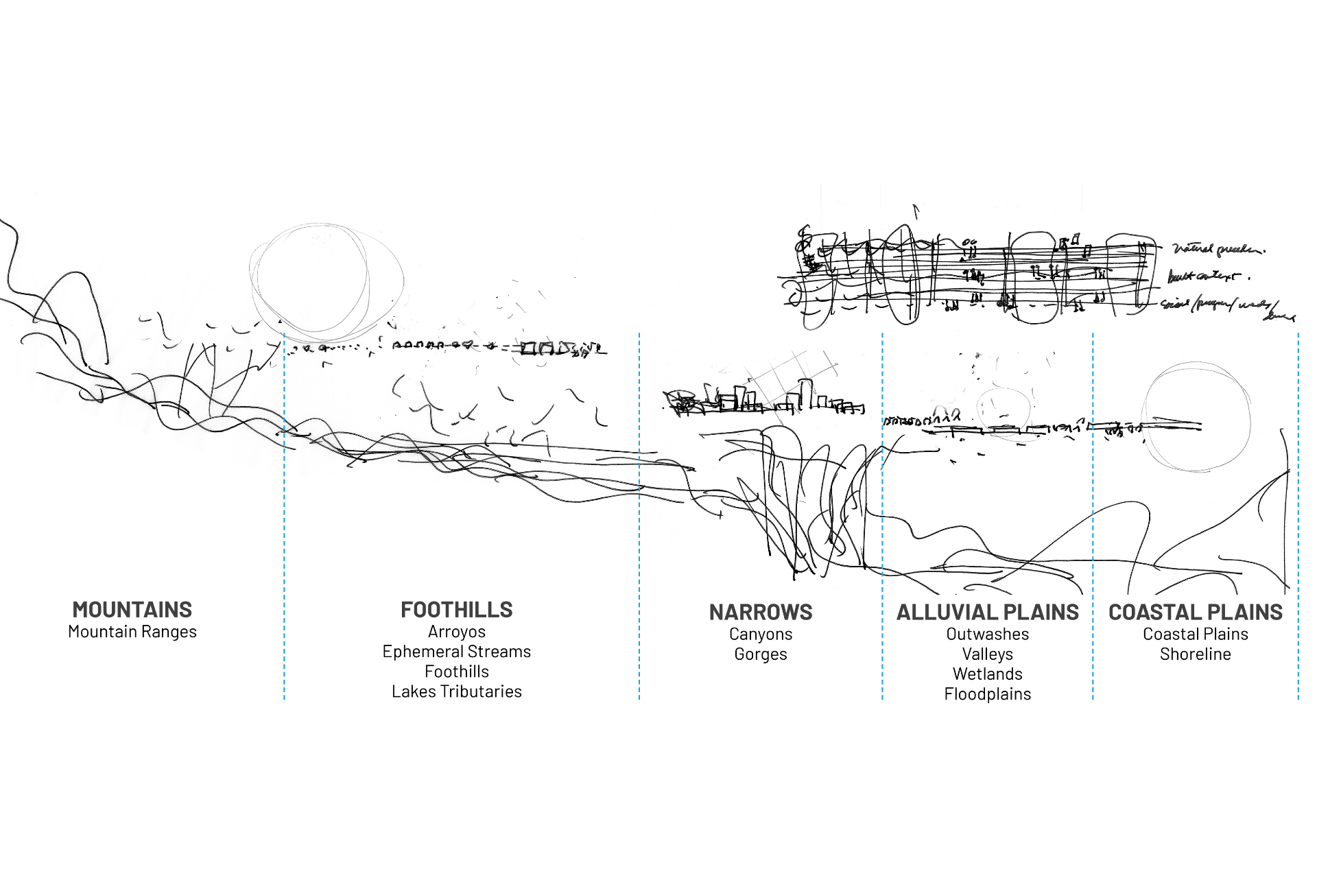
This conceptual sketch shows the varied environments of the LA River from the headwaters in the mountains to the mouth at the coastal plain shown as a longitudinal profile. Image from the LA River Master Plan 2021. Source: OLIN, 2016.
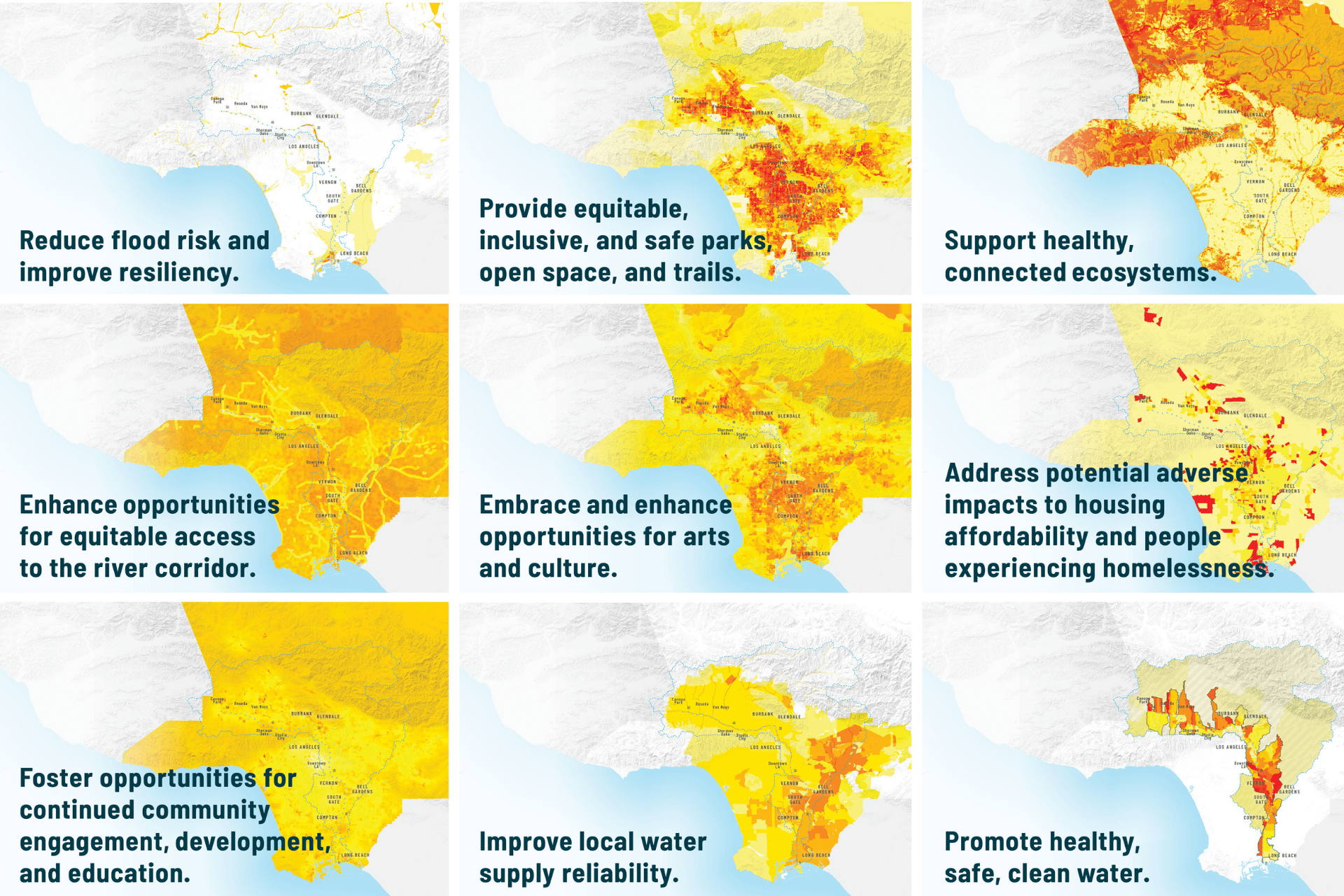
This image shows which portions of the LA River are most in need when it comes to fulfilling the goals of the Master Plan. The degree of need is reflected as general (yellow) to very high need (red). Image from the LA River Master Plan 2021
Click through the left and right arrows to view maps and sketches of the LA River.
Normal extremes are already severe. Marty Ralph, founder of the Center for Western Water and Weather Extremes at the Scripps Institution for Oceanography in San Diego, California, attests that Southern California has a precipitation differential two or three times greater than any place in the United States. The difference between a wet year and a dry year in Washington, D.C., might be four inches, give or take — a wet year gets 44 inches of rain, a dry one 36. In Southern California, the difference between a wet year and a dry year might be 20 inches more or less rainfall. As the climate warms, that “standard deviation” of 20 inches will only expand. The dry years will drag on in their deprivation; the wet years might bring floods at 50-, 30- or even 10-year intervals.
The history of Los Angeles is written in its street names, as well as in its remnant willows and sycamores. It is a history of water and swamps and floods.
And let’s be clear about it: None of these concrete channels are up to the task of containing a 100-year flood of the sort we last saw in the winter of 1861 to 1862. We’ve already seen in the U.S. what happens when flood events that are supposed to happen at long intervals pile up in just a few. At the close of the last decade, the charming village of Ellicott City, Maryland, whose buildings date back to before the American Revolution, suffered two destructive and deadly floods in as many years when the Patapsco River roared up beyond its banks with a fury that normally awakens once a millennium (the county won’t clear the floodplain — too many centuries-old buildings are at stake — but it’s at last at work on a stormwater basin). Europe has repeatedly been battered by heavy precipitation and high water in the past two decades; German Minister of the Environment Svenja Schulze has called the most recent floods “harbingers of climate change.”
***
But even in a chaotic climate, rivers don’t have to be evil and floods don’t have to be bad. In 1914, when James Reagan, who later became the first chief engineer of the Los Angeles Flood Control Agency, sent his deputies into the field to interview residents about flood solutions, he thought that in the wake of a punishing flood year he’d get more support for a dam. Instead, he mostly got lessons in natural hydrology. The interviews were never formally published, but you can find them at certain local libraries: 282 pages of oral histories called “Early Floods in Los Angeles County.” In them, farmers, fishermen and high-ranking officials whom Reagan’s deputies interrogated recall traveling by boat from the coast at San Pedro 15 miles inland to Compton; they told of houses built near washes being swept away in month-long storms. But instead of advocating for the kind of infrastructure Reagan had in mind, many of them simply blamed people for building in the wrong place. And they recognized that moving water had value.
“While floods in other lands are wholly evil in their effect,” 80-year-old historian James Miller Guinn told his interviewer. “Ours, although causing temporary damage, are greatly beneficial. They fill up the springs and mountain lakes and reservoirs that feed our creeks and rivers, and supply water for irrigation during the long dry season.
“A flood year,” he concluded, “is always followed by a fruitful year.”
Even the rocks, silt and sediment had a value. The big storms moved a great “mass of material” from the mountains to the lowlands, Guinn observed, but even an ordinary year’s rains carried a “small load of detritus down the sides of the mountains.” For that reason, Long Beach resident J.E. Proctor said in his interview, “It was not necessary to fertilize the land” to grow a crop of pumpkins “so thick that it was difficult to walk around and step between them.”
Another farmer, George Harris, warned that, “If the flood waters are not caught and used to replenish the underground flow, it will not be long before the underground supply of water gives out.” Harris observed that his own well had declined more than 15 feet in the time he’d been pumping; he estimated that, if the river were channelized, “in 25 years there will be no irrigating waters.” His forecast was on target: In 1955, fewer than 20 years after a catastrophic flood moved the Army Corps to lock up the Los Angeles River in concrete, the Central Basin aquifer under the plains of Los Angeles — a source upon which several Los Angeles County cities still depend — had run critically dry from excessive withdrawals without replenishment. The Water Replenishment District of Southern California was anointed by the state that year, tasked with finding water with which to fill it.
Reagan was out by 1928, but his essential philosophy – that rivers were enemies to be conquered and flowing water a force to be engineered away – prevailed. By the 1940s, the rocks, sand and silt with fecundity the county’s 19th-century farmers so enjoyed was contained behind upstream dams and sediment basins, never to nourish the landscape again.

Kizh-Gabrieleño tribe biologist Matthew Teutimez. Photo by Sam Slovick
“The amazing thing?” says Matt Teutimez as we stand overlooking the river from Steelhead Park, imagining uses for the invasive arrundo, the bamboo-like plant that crowds the far bank. “It hasn’t been that long. It’s been decades, not centuries.” It hasn’t even been long enough for the fish to forget where they used to spawn: Every once in a while, a steelhead trout bumps into Ballona Creek and tries to find its way back to its ancestral spawning grounds. “That’s what science calls site fidelity,” Teutimez says. “All of our creatures are imprinted that way.” He remembers his grand-uncle teaching the kids to fish in the Santa Ana River and has heard stories from living people “of human beings surviving off the sustenance coming” from the San Gabriel and, most of all, the Los Angeles River. “We call it Wenot,” Teutimez says. “The life-giver.” He doubts that it will ever give life again. “I know that this is not going to turn back to how it used to be,” he says, gesturing at the concrete river. But he can still advocate for its betterment.
As Teutimez says, it hasn’t been that long since we have paved over our landscapes, and it doesn’t have to take that long to uncover them.
De-channelization isn’t unheard of; it’s happened before in other places. The Kissimmee River, for instance, which wound through 103 miles of central Florida flanked by a 3-mile-wide floodplain that until the U.S. Army Corps, starting in the late 1940s, sliced off the river’s meanders and reduced it to a concrete canal. Just as biologists warned, 90 percent of the waterbirds that thrived in the river’s ecosystem disappeared; fish died off in the hypoxic channel. A restoration project that began in 1999 has returned 24 miles of the Kissimmee to its historic meandering route and restored 40 square miles of wetlands.
As Teutimez says, it hasn’t been that long since we have paved over our landscapes, and it doesn’t have to take that long to uncover them. It took only 11 years for the Dutch, those masters of flood control, to re-engineer the banks of their flood-prone rivers to make way for the climate-fueled storms that inevitably lie ahead. Instead of raising levees against the coming climate-fueled storms, they reclaimed the floodplains and gave the rivers more room to flow. The project, completed in 2018, was tested this past winter when the Rhine and Meuse rivers filled with snowmelt from Germany and France augmented by local rainfall. The event, said the Dutch Water Sector news service, “delivered spectacular views.”
Look how pretty it is, indeed.
No one is suggesting that the concrete that lines the Los Angeles River be ripped out tomorrow, riverside development be damned. It can’t be done in 10 years, or probably even 20. Perhaps it’s time to start the clock on another 40-year art project, in MacAdams’ memory, and make room for the river he loved. “It is not your duty to finish the work, but neither are you at liberty to neglect it,” wrote the wise scholars of the Jewish text Pirkei Avot.
So let’s not move backward. Let’s begin.
Help us sustain independent journalism...
Our team is working hard every day to bring you compelling, carefully-crafted pieces that shed light on the pressing issues of our time. We rely on caring supporters like you to help us sustain our mission. Your support ensures that we can continue to provide deeply-reported, independent, ad-free journalism without fear, favor or pandering. Support us today and make a lasting investment in the future.
RELATED STORIES


Award Winning


Today’s environmental and social justice challenges are unprecedented, and require an unprecedented collective effort.


Stay updated on our latest features, events and more. Subscribe to our Note From the Nest newsletter!